Discovering the 13th District of Budapest: A Tourist’s Dream Destination
Budapest’s 13th district blends history, modernity, and charm in the heart of the iconic Hungarian capital. As a tourist, you might wonder what makes this district stand out amidst the twenty-three districts of Budapest. Read on to unravel the magic of the 13th district!
Introduction
The 13th district, located on the Pest side of the Danube River, is an urban and modern part of Budapest that often remains overshadowed by its more famous counterparts. Fusing residential areas, office buildings, cultural sites, and parks offers a fresh perspective on the city.
Location
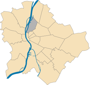
Beginning from the southernmost point of Népsziget, the boundary of District XIII follows the main branch and, subsequently, the Pest branch of the Danube up to the Margaret Bridge. It continues through Jászai Mari Square and along the Szent István Boulevard until it reaches Nyugati Square. From there, the boundary proceeds around the western and southeastern edges of the square towards Váci út.
Following Váci út, it extends to the Ferdinand Bridge, from where it moves along Lehel út and reaches Bulcsú Street. The boundary then makes its way to the entrance of the underpass, continuing towards the MÁV 28224 and follows the northwest boundary line of Mr. Dózsa György’s property up to Dózsa György út.
After crossing Dózsa György út, the boundary pursues Vágány utca and traces the former boundary line of District XIII leading to Róbert Károly körút. It then moves along Dévényi út, Szegedi út, and Tatai út up to Kámfor utca, following the MÁV railway line towards the Újpest boundary. From this point, it traces the old shared border of Budapest and Újpest to Göncöl utca and follows this street until it meets the MÁV railway once again.
Rejoining the northeastern side of the railway embankment, the boundary tracks back to the historical shared border between Újpest and Budapest, leading to the Újpest end of the connecting bridge. The boundary follows the historically shared border from this bridge again until it reaches the southern tip of Palotai Island. Finally, it goes along the central line of the main Danube branch, leading back to the starting point, the southern tip of Népsziget.
Geography
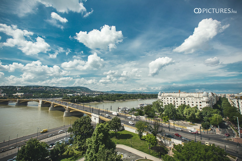
Situated primarily on the expansive Pest plain, this district stretches across various islands dotting the majestic Danube. The region’s lifeline, the Danube River, has significantly molded the district’s terrain. Until the 19th century, a considerable section known as Vizafogó remained marshland, only to be developed in the early 20th century. Notably, the area near the foot of the Árpád Bridge, including the lower quay and sections of Margaret Island, has been identified as a potential flood zone by the Budapest Civil Protection Directorate.
Another key watercourse enhancing the district’s character is the Rákos Stream, which seamlessly merges into the Danube. This stream, alongside the Danube, is channeled through concrete pathways along Tahi and Vizafogó streets.
A unique feature of this district is the southern half of Népsziget. In the 1830s, an innovative move saw the island’s northern tip linked to the Pest shore, or Újpest, through an embankment. This resulted in the formation of the Téli Kikötő (Winter Harbour), a sprawling 28.6-hectare bay. Once the beating heart of the Hungarian shipbuilding industry, this bay has now transformed into a haven for fishing aficionados and water sports enthusiasts.
Further south of the Újpesti Bay lies the man-made FOKA Bay, a product of extensive gravel mining. Today, the district is a testament to nature’s wonders and human ingenuity. Explore its rich landscapes and delve into its intriguing history.
Landmarks
The 13th district might not be as famous as Buda Castle or Heroes’ Square, but it has its share of landmarks. Some notable spots include:
- Margaret Island: A serene green haven amid the Danube, this island offers recreational facilities, medieval ruins, a small zoo, and more.
- Jászai Mari Square: A central point in the district that acts as a hub of transport and culture.
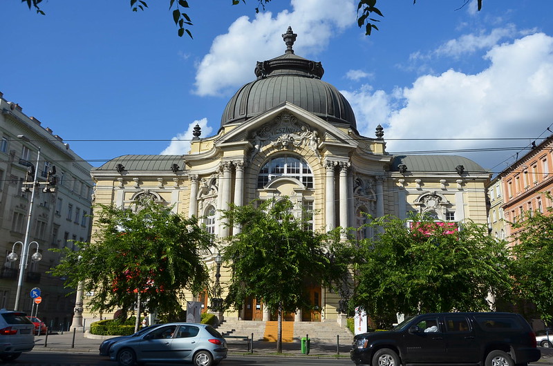
- Vígszínház: A renowned theater that has hosted countless classic performances.
History
Ancient Era: The early history of the region now known as District XIII in Budapest is largely shrouded in mystery. One of the most intriguing artifacts from its ancient past is the Angyalföld treasure, a gold find that dates back to the 8th century BC, hinting at the rich historical significance of the area. Before Roman colonization, Celtic tribes were the dominant groups in the region.
With the expansion of the Roman Empire, the province of Pannonia was established, with its border resting along the Danube. Though the primary Roman city in the vicinity was Aquincum on the western bank, the eastern bank wasn’t devoid of Roman presence. Transaquincum, a castrum or Roman military camp, was situated in today’s District XIII. Unfortunately, while its existence was hinted at in early 19th-century discoveries, the tangible remains of Transaquincum are largely lost to time, except for some Roman artifacts.
Hungarian Conquest and Medieval Times: The next significant historical reference hails from the Hungarian Conquest. According to Anonymus, a chronicler whose real identity remains a topic of debate, Árpád, the leader of the Hungarian tribes during their conquest of the Carpathian Basin, made camp in the Rákos field, believed to be situated in today’s District XIII. The subsequent reign of Árpád saw the territory controlled by the Esztergom Archbishop before it transitioned into royal donations. One of the settlements, known as Jenő, was particularly significant, possibly near today’s Újpest railway bridge.
As the Middle Ages progressed, King Béla IV played a crucial role in redistributing lands in the region. He reclaimed Jenő and granted it along with surrounding territories like Új-Bécs, Vizafogó, and Rákosmező to religious orders, cementing the church’s influence in the region.
Late Medieval Period to the End of Turkish Rule: Between 1298 and 1526, the Diets of Rákosmező rendered the region politically significant. These assemblies were vital in shaping Hungarian medieval politics. However, the subsequent periods, especially following the death of King Louis II, were tumultuous for the region. The Turkish occupation, which followed the Battle of Mohács in 1526, coupled with internal strife, led to substantial demographic and socio-economic changes. The frequent wars and the declining influence of Pest decimated the local population. By the late 18th century, settlements that once thrived, such as Jenő and Új-Bécs, had vanished.
Post-Ottoman Growth: The momentum following Buda’s liberation was quickly captured by District XIII. As Pest began to flourish, the areas outside its walls, particularly in the region of District XIII, transformed into bustling hubs for commerce, thanks to the fairs. The district didn’t remain immune to calamities, as demonstrated by the devastating flood of 1838, which led to the construction of dikes and the filling of the Rákos ditch. This period also witnessed a blend of recreational activities, with locals frequenting Angyalföld for leisure, even as urbanization started taking shape, especially in Lipótváros.
The Industrial Boom: The second half of the 19th century saw Angyalföld emerge as a pivotal hub for Hungarian engineering and industrialization. This transformation can be attributed to pioneers like Antal Höcker and László Láng, who established factories that became precursors to some of Hungary’s key industries. For instance, shipbuilding commenced in Újpest Bay in 1856, and the Láng Machine Works grew from Láng’s initial machine repair workshop.
Infrastructure Development: The district’s growth was further bolstered by infrastructural developments. Major roads like the Váci Street were expanded, and monumental bridges like the Margaret Bridge began construction. This flurry of roadwork culminated with the completion of the Róbert Károly körút (formerly Hungária út) by 1879. The unification of Budapest also paved the way for new developments, including the construction of the Lipót körút. With Lipótváros transforming, factories relocated, making room for upscale residential areas with a notable Jewish bourgeoisie populace.
Connecting the District: Transportation links, like the opening of the Nyugati railway station and the Újpest railway bridge, connected District XIII even more closely with the rest of the capital. The district’s inclusion in the tramway system further integrated it into the city’s transit network.
The World Wars and Beyond: The First World War disrupted the district’s industrial ascendancy, with factories either transitioning to wartime production or shutting down. However, the post-war era brought renewed vigor. New establishments emerged, such as the Silk and Wool Factory and the Anglo-Hungarian Thread Factory Ltd. Yet, the density of the worker populace led to housing challenges, resulting in cramped living conditions. The period also observed heightened political activism among workers, culminating in events like the Great Budapest Workers’ Demonstration of 1930, which originated in Angyalföld.
The economic downturn of 1929 further strained the district. However, the subsequent period experienced another resurgence in industrial activities. Emblematic of this was the founding of industries like the Elzett Ironworks, which held significant national importance.
The Industrial Boom and Urban Expansion: The surging manufacturing industry significantly changed the urban landscape. Overcrowding became a pressing issue, leading to the quick solution of erecting wooden shacks, which unfortunately did little to enhance living conditions. The capital’s first people’s hostel was constructed to combat this, alongside the People’s House on Vág Street in 1910-11. This provided a residential space and acted as a cultural hub. Another major construction during this period was the Palotai Street housing estate, known colloquially as Tripolis, between 1911 and 1912.
Education and Culture: Angyalföld saw its first school in 1872, but the major cultural strides happened at the turn of the century. On 1 May 1896, the Comedy Theatre was inaugurated on Lipót körút, being the fourth such establishment in the capital and approved as part of the preparations for the Millennium Celebrations.
Theatrical Renaissance: The turn of the century marked a theatrical boom in the district. The People’s House Theatre, established in 1911, had an eclectic range of plays. An avant-garde group named ‘the Workshop’ began its operations at Népszínház in 1924, continuing until the late 1930s. Mihály Erdélyi’s Angyalföld Stage, established in 1930, offered affordable theatre to its association members but, unfortunately, had a short-lived existence.
The Rise of Cinemas: The cinema culture also saw an explosion in popularity. In 1910, the Winkler Cinema opened, boasting a generous seating capacity for its time. Other cinemas like the Elit Mozgó, Diana Cinema, and Nép mozgó sprouted around the district. Angyalföld was even home to Hungary’s first film factory, Hunnia Biográf, in 1917, although a windstorm tragically destroyed it in 1921. While some cinemas faded with the advent of sound films, others emerged, adapting to the increasing audience expectations.
Religious Establishments: The churches played an instrumental role in the area’s civilizational journey. The industrial region saw the Carmelites constructing the first church on Huba Street in Angyalföld in 1899, providing spiritual nourishment to the community.
Sporting Initiatives: The turn of the century also witnessed the genesis of sports clubs in the district. Vasas SC, one of the significant sporting entities, was founded in 1911.
The late 19th and early 20th centuries in Angyalföld symbolize a period of transformation, where the district not only underwent urbanization but also saw the rise of a rich tapestry of cultural, religious, and sporting activities. This era set the foundation for Angyalföld’s modern identity, melding its industrial heritage with cultural vibrancy.
Formation of the District: District XIII was established in 1938 following Act XVIII of 1930, which expanded the number of districts in Budapest from 10 to 14. The new District XIII was carved out of parts of Districts V and VI, encompassing regions like Vizafogó, Nép-sziget, Lőportár-dűlő, and Angyalföld. The district was christened Magdolnaváros in honor of Magdalena Purgly, the governor’s wife.
World War II Era: During the Second World War, District XIII, particularly Angyalföld, became a hub for resistance movements. These movements grew even stronger after the Arrow Cross Party took control in 1944. Various resistance groups worked covertly, with a major unit led by Lieutenant Lajos Gidófalvy. Their primary roles included sabotage, assisting deserters, and thwarting efforts to capture and destroy factory equipment.
A significant number of persecuted Jews found refuge in “sheltered houses” within the Újlipótváros area of the district. In recognition of Raoul Wallenberg, a Swedish diplomat who played a pivotal role in saving many Jews, a street and a monument were dedicated to his memory in the district. The endeavors of Ángel Sanz Briz and Giorgio Perlasca, who were instrumental in saving Jews, are commemorated with plaques in St. Stephen’s Park.
Post-war Changes: In 1950, adjustments to district boundaries brought parts of District V, a segment of District VI, and Margaret Island from District III into District XIII. District councils were created in Budapest, and the first council for District XIII had 101 members. This merging of different regions posed challenges, as disparities in development created tensions among residents.
During the 1956 revolution, District XIII remained relatively unscathed compared to some central districts of Budapest.
Urban Development in the Latter Half of the 20th Century: From the late 1950s onward, housing development was undertaken in District XIII in response to immigration trends and many workers’ subpar living conditions. Through the late 1980s, prefabricated housing estates were constructed, transforming areas like Tahi útti, Árpád hídi, and Béke-Tatai utca. The Kárpát utca housing estate was a notable development of this era.
Traffic congestion became a growing concern, with the district’s roads witnessing increased vehicle use. The Árpád Bridge underwent expansion between 1980 and 1984 to accommodate the rising traffic. Additionally, the M3 metro line’s extension to Élmunkás Square in 1981, and subsequently to Újpest Centre in 1990, significantly bolstered the district’s transportation infrastructure.
District XIII after the Regime Change
Following the regime change in Hungary, which marked the transition from a socialist system to a multi-party democracy in the late 20th century, Budapest’s District XIII experienced significant alterations in its socio-economic and urban fabric.
1. Governance: The district underwent structural changes in governance. The last council meeting occurred in 1990, and an elected Municipality subsequently assumed control of the district’s administration. This shift mirrored the broader national changes as Hungary transitioned to democratic governance.
2. Economic Transformation: The district was heavily industrialized before the regime change. The post-change era saw this industrial character gradually fade, creating a trade and service-based economy. Many large factories that once symbolized the district’s industrial might were demolished or redeveloped. In their place, many office buildings sprang up along the district’s main routes. This shift from industry to commerce was symbolized by the opening of Duna Plaza in 1996, a Western-style shopping center built on the grounds of a former shipyard.
3. Real Estate Development: The post-regime change period witnessed robust real estate activities. Both the 1990s and the 2000s saw substantial residential development. Projects ranged from new housing developments, like the Cézár House, to renovations of older structures and entirely new constructions in previously undeveloped areas, such as the Marina Beach. Between 2000 and 2010 alone, the district completed over 14,000 new-build apartments. In addition, there was a noticeable shift in housing policy. After the regime change, the district government initiated the sale of a significant portion of council housing. More recently, there has been a focus on constructing owner-occupied apartment blocks.
4. Recognition: The district’s efforts in sustainable and integrated urban development did not go unnoticed. In 2012, the Hungarian Urbanists’ Association recognized District XIII’s two decades of strategic urban development by awarding it the János Hild Prize.
In summary, the regime change heralded a period of intense transformation for District XIII. From governance and economic activities to urban development, the district underwent sweeping changes, effectively modernizing its character and adapting to the needs and opportunities of a new era.
Education
Education is a strong suit of the 13th district. Several schools cater to different age groups and curricula, making the district ideal for families. Some institutions focus on higher education, such as the Metropolitan University.
Museums
For culture enthusiasts, this district offers a range of museums:
- The Local History Collection of Angyalföld presents the history of the XIII. district in permanent, temporary, and traveling exhibitions, located at Váci út, number 50.
- Al Gallery can be visited in Lőportár Street
- Duna Gallery is located at the corner of Pannónia Street and Dráva Street.
- The district-managed Újlipótvárossi Klub-Galéria has been operating on Tátra Street since 1994, mainly hosting exhibitions by district artists. Since 1996, it has been the headquarters of the District XIII Fine and Applied Artists Association.
- City Hall Gallery is located on Peace Square.
Twin Towns
- Austria: Vienna- Floridsdorf
- Croatia: Osijek
- Slovakia: Kosice-South
- Romania: Szováta
- Poland: Warsaw – Ochota
Google Maps of Angyalföld, Göncz Árpád városközpont, Újlipótváros, Vizafogó (District 13)
Conclusion
Budapest’s 13th district is a testament to the city’s evolution. The district is a rich tapestry of history, culture, and modernity, from humble agricultural beginnings to bustling urban space. It’s an essential visit for those who wish to see a different side of Budapest beyond the traditional tourist trail.