The Topographical Tapestry of Budapest
Budapest, often referred to as the “Heart of the Carpathian Basin,” is strategically nestled at the core of this geographical region. This positioning places it on an age-old route that bridges the Transdanubian hills with the expansive Great Plain. To give a perspective on its location, Budapest is 216 kilometers (134 mi) southeast of Vienna, 545 kilometers (339 mi) south of Warsaw, 1,565 kilometers (972 mi) southwest of Moscow, 1,122 kilometers (697 mi) north of Athens, 788 kilometers (490 mi) northeast of Milan, and 443 kilometers (275 mi) southeast of Prague.
Spanning an area of 525 square kilometers (203 sq mi), Budapest is enveloped by the settlements of Pest County’s agglomeration. The city stretches approximately 25 km (16 mi) north-south and 29 km (18 mi) east-west. The majestic Danube River gracefully flows into the city from the north, wrapping around two significant islands: Óbuda Island and Margaret Island. Another island, Csepel Island, is the largest among the Danube islands in Budapest, though only its northern tip falls within the city’s boundaries. At its narrowest in Budapest, the Danube spans a width of 230 m (755 ft).
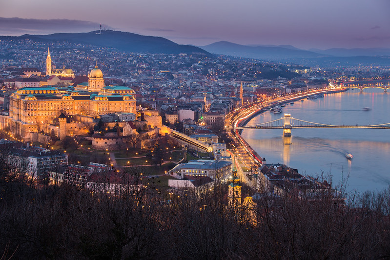
The city’s topography presents a stark contrast. While Pest sprawls across the flat terrains of the Great Plain, Buda is perched on the elevated river terraces and hills on the Danube’s western bank. This difference is accentuated by the river that divides the city. Buda’s landscape is dotted with hills primarily made of limestone and dolomite. These hills house renowned speleothems like the Pálvölgyi cave, stretching 7,200 m (23,600 ft), and the Szemlőhegyi cave, which is 2,200 m (7,200 ft) long. These hills took shape during the Triassic Period. The city’s highest point is János Hill, standing tall at 527 meters (1,729 feet) above sea level. In contrast, the Danube’s line is the city’s lowest point, at 96 meters (315 feet) above sea level.

Budapest is not just about urban landscapes; it’s also a haven for nature lovers. Out of its 525 square kilometers (203 square miles) expanse, a whopping 83 square kilometers (32 square miles) is dedicated to green spaces, parks, and forests. The Buda Hills forests, in particular, are under environmental protection, ensuring they remain untouched for future generations.

Budapest’s geographical location has made it a pivotal point in terms of transportation. Numerous major European roads and railway lines converge here. The Danube has always been a significant waterway, and Budapest’s central position in the Carpathian Basin places it at the intersection of several trade routes.

A unique feature that sets Budapest apart from most global capitals is its thermal springs. It’s one of only three capital cities worldwide blessed with these springs, the other two being Reykjavík in Iceland and Sofia in Bulgaria. The city boasts about 125 springs that gush out 70 million liters (15,000,000 imperial gallons; 18,000,000 US gallons) of thermal water daily. These waters can get as warm as 58 Celsius. Rich in minerals, many of these springs are believed to have therapeutic properties, offering both relaxation and healing to those who seek it.

In essence, Budapest is a blend of historical significance, geographical wonders, and natural beauty, making it a must-visit for travelers and nature enthusiasts alike.